FROM: NWS Paducah KY
ENENT: Severe Thunderstorm Warning
AREA: Daviess, KY; Henderson, KY; Hopkins, KY; McLean, KY; Muhlenberg, KY; Webster, KY
SENT: 2026-04-27T23:56:00-05:00
A Tornado Watch remains in effect until 500 AM CDT for south central
and northwestern Kentucky.
Remain alert for a possible tornado! Tornadoes can develop quickly
from severe thunderstorms. If you spot a tornado go at once into the
basement or small central room in a sturdy structure.
For your protection move to an interior room on the lowest floor of a
building.
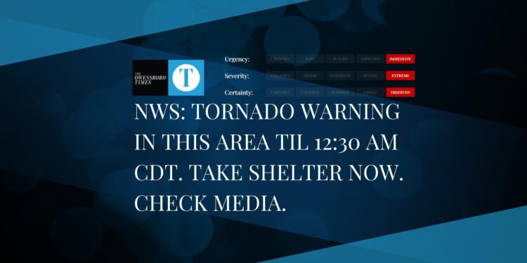
Severe Thunderstorm Warning issued April 27 at 11:56PM CDT until April 28 at 12:30AM CDT by NWS Paducah KY
At 1156 PM CDT, severe thunderstorms were located along a line
extending from near Robards to near Dixon, moving east at 60 mph.
HAZARD…60 mph wind gusts and penny size hail.
SOURCE…Radar indicated.
IMPACT…Expect damage to roofs, siding, and trees.
Locations impacted include…
Central City, Calhoun, Sebree, Livermore, St. Joseph, Beech Grove,
Hanson, Sacramento, Island, Slaughters, Bremen, South Carrollton, and
Moseleyville.
This includes the following highways…
Interstate 165 between Mile Markers 60 and 63.
Interstate 69 in Kentucky between Mile Markers 120 and 140.
Western Kentucky Parkway between Mile Markers 60 and 65.
Alert Expiration: 2026-04-28T00:30:00-05:00