URGENT – IMMEDIATE BROADCAST REQUESTED
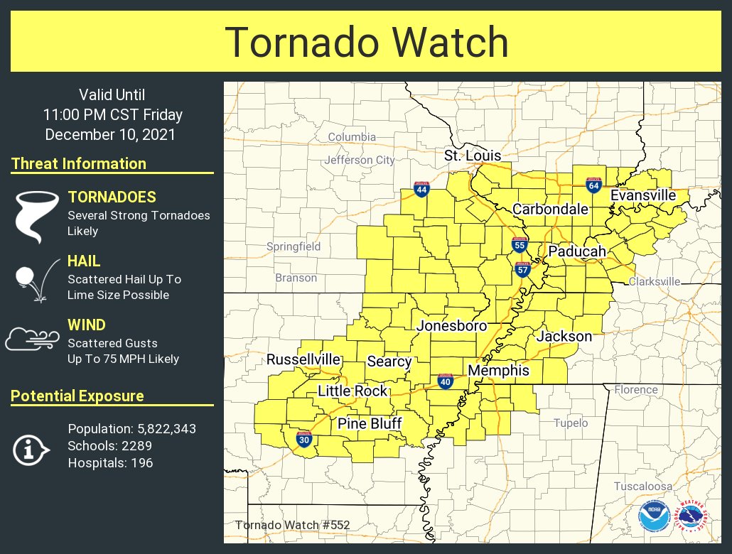
Tornado Watch Number 552
NWS Storm Prediction Center Norman OK
300 PM CST Fri Dec 10 2021
The NWS Storm Prediction Center has issued a
- Tornado Watch for portions of
Central and northeastern Arkansas
Southern Illinois
Southwestern Indiana
Western Kentucky
Southeastern Missouri
Northwestern Mississippi
Western Tennessee - Effective this Friday afternoon and evening from 300 PM until
1100 PM CST. - Primary threats include…
Several tornadoes and a couple intense tornadoes likely
Scattered damaging winds likely with isolated significant gusts
to 75 mph possible
Scattered large hail and isolated very large hail events to 2
inches in diameter possible
SUMMARY…Scattered supercell development is expected this afternoon
through early tonight from central Arkansas northeastward toward the
confluence of the Mississippi and Ohio Rivers. Other storm
development is expected early tonight along a cold front moving into
Missouri and Arkansas. The storm environment will favor the
potential for a few strong tornadoes this evening through early
tonight, as well as damaging winds and large hail.
The tornado watch area is approximately along and 100 statute miles
east and west of a line from 10 miles west southwest of Pine Bluff
AR to 35 miles northeast of Carbondale IL. For a complete depiction
of the watch see the associated watch outline update (WOUS64 KWNS
WOU2).
PRECAUTIONARY/PREPAREDNESS ACTIONS…
REMEMBER…A Tornado Watch means conditions are favorable for tornadoes and severe thunderstorms in and close to the watch
area. Persons in these areas should be on the lookout for
threatening weather conditions and listen for later statements
and possible warnings.
&&
AVIATION…Tornadoes and a few severe thunderstorms with hail
surface and aloft to 2 inches. Extreme turbulence and surface wind
gusts to 65 knots. A few cumulonimbi with maximum tops to 500. Mean
storm motion vector 24050.
…Thompson